Yale NUS walking
- Distance: 1.4 Km
- Elevation gain: 31 m
- Maximum elevation: 25 m
- Elevation loss: 13 m
- Minimum elevation: 4 m
- Moving time: 19 m 28 s
- Moving speed: 4.5 Km/h
- Maximum speed: 32.4 Km/h
- Total time: 22 m 38 s
- Global speed: 3.8 Km/h
Interactive trail map
Trail profile
- Distance: 1.4 Km
- Elevation gain: 31 m
- Maximum elevation: 25 m
- Elevation loss: 13 m
- Minimum elevation: 4 m
- Moving time: 19 m 28 s
- Moving speed: 4.5 Km/h
- Maximum speed: 32.4 Km/h
- Total time: 22 m 38 s
- Global speed: 3.8 Km/h
About this trail
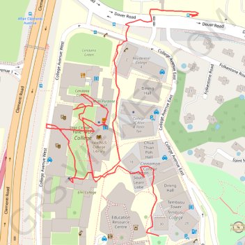
Name: Yale NUS walking trail, distance, elevation, map, profile, GPS track
Coordinates: 1.30574 103.77178 1.30910 103.77403
Other hiking, mountain biking, running and outdoor activity trails
Click on a trail to view its statistics, map and profile.
The Green Corridor - Singapore
Distance: 22.3 Km • Elevation gain: 167 m • Maximum elevation: 44 m
Directions from Duck Tour Ramp to Marina Boulevard, Singapore
Distance: 105.3 Km • Elevation gain: 812 m • Maximum elevation: 51 m