Make a donation
Gear up for your next adventure:
As an Amazon Associate, this site earns from qualifying purchases at no extra cost to you.
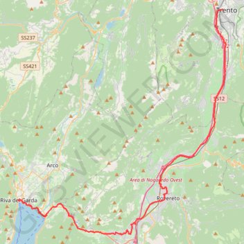
2022_DE_Trient-Riva del Garda
- Distance: 51.1 Km
- Elevation gain: 377 m
- Maximum elevation: 276 m
- Elevation loss: 511 m
- Minimum elevation: 62 m
Interactive trail map
Make a donation
Gear up for your next adventure:
As an Amazon Associate, this site earns from qualifying purchases at no extra cost to you.
Trail profile
- Distance: 51.1 Km
- Elevation gain: 377 m
- Maximum elevation: 276 m
- Elevation loss: 511 m
- Minimum elevation: 62 m
Make a donation
Gear up for your next adventure:
As an Amazon Associate, this site earns from qualifying purchases at no extra cost to you.
About this trail
Name: 2022_DE_Trient-Riva del Garda trail, distance, elevation, map, profile, GPS track
Coordinates: 45.85138 10.83902 46.06723 11.12464
Make a donation
Gear up for your next adventure:
As an Amazon Associate, this site earns from qualifying purchases at no extra cost to you.
Other hiking, mountain biking, running and outdoor activity trails
Click on a trail to view its statistics, map and profile.
Riva del Garda - Pergine Valsugana
Italy > Trentino – Alto Adige/Südtirol > Provincia di Trento > Riva del Garda > Sant'Alessandro > Alboletta
One-way between Riva del Garda and Pergine Valsugana.
Distance: 193.3 Km • Elevation gain: 5,511 m • Maximum elevation: 2,038 m
2022_DE_Bozen-Trient | flach
Italy > Trentino – Alto Adige/Südtirol > South Tyrol > Bolzano - Bozen
Distance: 65.7 Km • Elevation gain: 300 m • Maximum elevation: 274 m