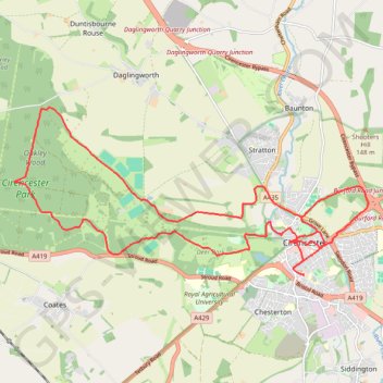
Ciren Park Loop
- Distance: 23.5 Km
- Elevation gain: 176 m
- Maximum elevation: 183 m
- Elevation loss: 176 m
- Minimum elevation: 109 m
- Moving time: 4 h 16 m
- Moving speed: 5.5 Km/h
- Maximum speed: 10.8 Km/h
- Total time: 6 h 33 m
- Global speed: 3.6 Km/h
Interactive trail map
Trail profile
- Distance: 23.5 Km
- Elevation gain: 176 m
- Maximum elevation: 183 m
- Elevation loss: 176 m
- Minimum elevation: 109 m
- Moving time: 4 h 16 m
- Moving speed: 5.5 Km/h
- Maximum speed: 10.8 Km/h
- Total time: 6 h 33 m
- Global speed: 3.6 Km/h
About this trail
Name: Ciren Park Loop trail, distance, elevation, map, profile, GPS track
Coordinates: 51.71162 -2.04345 51.73933 -1.94933
Other hiking, mountain biking, running and outdoor activity trails
Click on a trail to view its statistics, map and profile.
Baunton Cirencester
United Kingdom > England > Gloucestershire > Cotswold District > Cirencester > Chesterton
Distance: 23.3 Km • Elevation gain: 181 m • Maximum elevation: 174 m
Cirencester, Baunton and Shooters Hill Loop
United Kingdom > England > Gloucestershire > Cotswold District > Cirencester > Chesterton
Distance: 15.0 Km • Elevation gain: 132 m • Maximum elevation: 174 m
Thames Head Loop Hike
United Kingdom > England > Gloucestershire > Cotswold District > Cirencester > Chesterton
Distance: 20.2 Km • Elevation gain: 150 m • Maximum elevation: 165 m
Cirencester Dobbies
United Kingdom > England > Gloucestershire > Cotswold District > Cirencester > Chesterton
Distance: 9.8 Km • Elevation gain: 45 m • Maximum elevation: 117 m
Dean2023-311
United Kingdom > England > Oxfordshire > Oxford
Distance: 310.3 Km • Elevation gain: 3,366 m • Maximum elevation: 290 m
Cirencester north
United Kingdom > England > Gloucestershire > Cotswold District > Cirencester > Chesterton
Distance: 11.9 Km • Elevation gain: 118 m • Maximum elevation: 153 m
Cirencester Park
United Kingdom > England > Gloucestershire > Cotswold District > Cirencester > Chesterton
Distance: 16.1 Km • Elevation gain: 126 m • Maximum elevation: 184 m