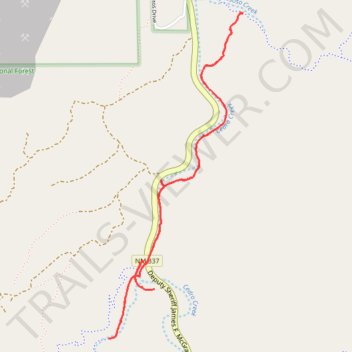
Cedro Creek Trail in Cibola National Forest
- Distance: 5.5 Km
- Elevation gain: 127 m
- Maximum elevation: 2,031 m
- Elevation loss: 127 m
- Minimum elevation: 1,973 m
- Moving time: 1 h 25 m
- Moving speed: 3.9 Km/h
- Maximum speed: 8.2 Km/h
- Total time: 1 h 31 m
- Global speed: 3.6 Km/h
Interactive trail map
Trail profile
- Distance: 5.5 Km
- Elevation gain: 127 m
- Maximum elevation: 2,031 m
- Elevation loss: 127 m
- Minimum elevation: 1,973 m
- Moving time: 1 h 25 m
- Moving speed: 3.9 Km/h
- Maximum speed: 8.2 Km/h
- Total time: 1 h 31 m
- Global speed: 3.6 Km/h
About this trail
Name: Cedro Creek Trail in Cibola National Forest trail, distance, elevation, map, profile, GPS track
Start: Tunnel Canyon Trailhead, Bernalillo County, New Mexico, 87059, United States (35.04656 -106.38305)
End: Tunnel Canyon Trailhead, Bernalillo County, New Mexico, 87059, United States (35.04655 -106.38306)
Coordinates: 35.04247 -106.38531 35.05963 -106.37665