Thank you for supporting this site ❤️
Make a donation
Make a donation
Gear up for your next adventure:
As an Amazon Associate, this site earns from qualifying purchases at no extra cost to you.
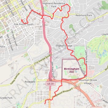
Walking Five Points, Highland Park, Key Circle, Botanical Gardens, Mountain Brook Village
- Distance: 9.1 Km
- Elevation gain: 157 m
- Maximum elevation: 296 m
- Elevation loss: 143 m
- Minimum elevation: 202 m
- Moving time: 2 h 31 m
- Moving speed: 3.6 Km/h
- Maximum speed: 9.9 Km/h
- Total time: 3 h 46 m
- Global speed: 2.4 Km/h
Interactive trail map
Thank you for supporting this site ❤️
Make a donation
Make a donation
Gear up for your next adventure:
As an Amazon Associate, this site earns from qualifying purchases at no extra cost to you.
Trail profile
- Distance: 9.1 Km
- Elevation gain: 157 m
- Maximum elevation: 296 m
- Elevation loss: 143 m
- Minimum elevation: 202 m
- Moving time: 2 h 31 m
- Moving speed: 3.6 Km/h
- Maximum speed: 9.9 Km/h
- Total time: 3 h 46 m
- Global speed: 2.4 Km/h
Thank you for supporting this site ❤️
Make a donation
Make a donation
Gear up for your next adventure:
As an Amazon Associate, this site earns from qualifying purchases at no extra cost to you.
About this trail
Name: Walking Five Points, Highland Park, Key Circle, Botanical Gardens, Mountain Brook Village trail, distance, elevation, map, profile, GPS track
Coordinates: 33.47718 -86.79718 33.50645 -86.77417
Thank you for supporting this site ❤️
Make a donation
Make a donation
Gear up for your next adventure:
As an Amazon Associate, this site earns from qualifying purchases at no extra cost to you.