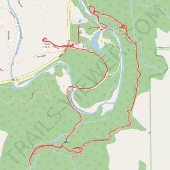
Whitewater State Park - Chimney Rock, Inspiration Point and Coyote Point loop
- Distance: 5.4 Km
- Elevation gain: 195 m
- Maximum elevation: 341 m
- Elevation loss: 195 m
- Minimum elevation: 252 m
- Moving time: 1 h 44 m
- Moving speed: 3.1 Km/h
- Maximum speed: 12.2 Km/h
- Total time: 2 h 51 m
- Global speed: 1.9 Km/h
Interactive trail map
Trail profile
- Distance: 5.4 Km
- Elevation gain: 195 m
- Maximum elevation: 341 m
- Elevation loss: 195 m
- Minimum elevation: 252 m
- Moving time: 1 h 44 m
- Moving speed: 3.1 Km/h
- Maximum speed: 12.2 Km/h
- Total time: 2 h 51 m
- Global speed: 1.9 Km/h
About this trail
Name: Whitewater State Park - Chimney Rock, Inspiration Point and Coyote Point loop trail, distance, elevation, map, profile, GPS track
Start: State Highway 74, Elba Township, Winona County, Minnesota, United States (44.05429 -92.04503)
End: State Highway 74, Elba Township, Winona County, Minnesota, United States (44.05448 -92.04587)
Coordinates: 44.04568 -92.05028 44.05572 -92.04045