Thank you for supporting this site ❤️
Make a donation
Make a donation
Gear up for your next adventure:
As an Amazon Associate, this site earns from qualifying purchases at no extra cost to you.
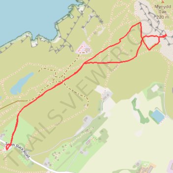
Mynydd Tŵr, Caergybi
- Distance: 3.1 Km
- Elevation gain: 111 m
- Maximum elevation: 162 m
- Elevation loss: 111 m
- Minimum elevation: 94 m
- Moving time: 58 m
- Moving speed: 3.2 Km/h
- Maximum speed: 26.1 Km/h
- Total time: 3 h 51 m
- Global speed: 0.8 Km/h
Interactive trail map
Thank you for supporting this site ❤️
Make a donation
Make a donation
Gear up for your next adventure:
As an Amazon Associate, this site earns from qualifying purchases at no extra cost to you.
Trail profile
- Distance: 3.1 Km
- Elevation gain: 111 m
- Maximum elevation: 162 m
- Elevation loss: 111 m
- Minimum elevation: 94 m
- Moving time: 58 m
- Moving speed: 3.2 Km/h
- Maximum speed: 26.1 Km/h
- Total time: 3 h 51 m
- Global speed: 0.8 Km/h
Thank you for supporting this site ❤️
Make a donation
Make a donation
Gear up for your next adventure:
As an Amazon Associate, this site earns from qualifying purchases at no extra cost to you.
About this trail
Name: Mynydd Tŵr, Caergybi trail, distance, elevation, map, profile, GPS track
Start: South Stack Road, Trearddur, Isle of Anglesey, Wales, LL65 1YH, United Kingdom (53.30480 -4.69061)
End: South Stack Road, Trearddur, Isle of Anglesey, Wales, LL65 1YH, United Kingdom (53.30480 -4.69061)
Coordinates: 53.30480 -4.69066 53.31218 -4.67524
Thank you for supporting this site ❤️
Make a donation
Make a donation
Gear up for your next adventure:
As an Amazon Associate, this site earns from qualifying purchases at no extra cost to you.