ציורי הסלע, הטומולוסים והר ערקוב
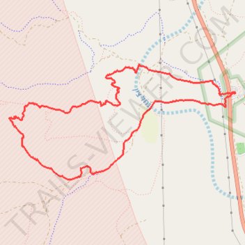
- Distance: 9.4 Km
- Elevation gain: 232 m
- Maximum elevation: 652 m
- Elevation loss: 232 m
- Minimum elevation: 519 m
- Moving time: 1 h 40 m
- Moving speed: 5.6 Km/h
- Maximum speed: 32.9 Km/h
- Total time: 1 h 51 m
- Global speed: 5.1 Km/h
Interactive trail map
Trail profile
- Distance: 9.4 Km
- Elevation gain: 232 m
- Maximum elevation: 652 m
- Elevation loss: 232 m
- Minimum elevation: 519 m
- Moving time: 1 h 40 m
- Moving speed: 5.6 Km/h
- Maximum speed: 32.9 Km/h
- Total time: 1 h 51 m
- Global speed: 5.1 Km/h
About this trail
Name: ציורי הסלע, הטומולוסים והר ערקוב trail, distance, elevation, map, profile, GPS track
Start: 40, Ramat Negev Regional Council, Beersheba Subdistrict, South District, Israel (30.79234 34.76861)
End: 40, Ramat Negev Regional Council, Beersheba Subdistrict, South District, Israel (30.79225 34.76868)
Coordinates: 30.78230 34.73829 30.79551 34.76868