Thank you for supporting this site ❤️
Make a donation
Make a donation
Gear up for your next adventure:
As an Amazon Associate, this site earns from qualifying purchases at no extra cost to you.
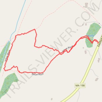
Walked the loop trail at the Thompson Family Forever Wild Preserve
- Distance: 2.2 Km
- Elevation gain: 48 m
- Maximum elevation: 245 m
- Elevation loss: 49 m
- Minimum elevation: 211 m
- Moving time: 47 m 32 s
- Moving speed: 2.7 Km/h
- Maximum speed: 5.7 Km/h
- Total time: 55 m 19 s
- Global speed: 2.3 Km/h
Interactive trail map
Thank you for supporting this site ❤️
Make a donation
Make a donation
Gear up for your next adventure:
As an Amazon Associate, this site earns from qualifying purchases at no extra cost to you.
Trail profile
- Distance: 2.2 Km
- Elevation gain: 48 m
- Maximum elevation: 245 m
- Elevation loss: 49 m
- Minimum elevation: 211 m
- Moving time: 47 m 32 s
- Moving speed: 2.7 Km/h
- Maximum speed: 5.7 Km/h
- Total time: 55 m 19 s
- Global speed: 2.3 Km/h
Thank you for supporting this site ❤️
Make a donation
Make a donation
Gear up for your next adventure:
As an Amazon Associate, this site earns from qualifying purchases at no extra cost to you.
About this trail
Name: Walked the loop trail at the Thompson Family Forever Wild Preserve trail, distance, elevation, map, profile, GPS track
Coordinates: 42.04579 -72.06698 42.04873 -72.05850
Thank you for supporting this site ❤️
Make a donation
Make a donation
Gear up for your next adventure:
As an Amazon Associate, this site earns from qualifying purchases at no extra cost to you.