Maymount Park Japanese Garden Loop
- Distance: 1.4 Km
- Elevation gain: 38 m
- Maximum elevation: 60 m
- Elevation loss: 31 m
- Minimum elevation: 26 m
- Moving time: 29 m 39 s
- Moving speed: 2.9 Km/h
- Maximum speed: 8.6 Km/h
- Total time: 46 m 28 s
- Global speed: 1.8 Km/h
Interactive trail map
Trail profile
- Distance: 1.4 Km
- Elevation gain: 38 m
- Maximum elevation: 60 m
- Elevation loss: 31 m
- Minimum elevation: 26 m
- Moving time: 29 m 39 s
- Moving speed: 2.9 Km/h
- Maximum speed: 8.6 Km/h
- Total time: 46 m 28 s
- Global speed: 1.8 Km/h
About this trail
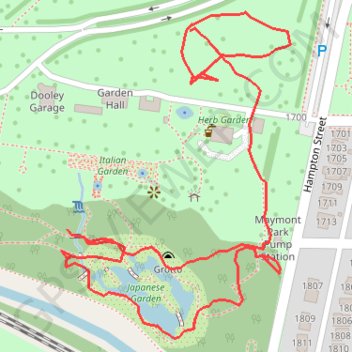
Name: Maymount Park Japanese Garden Loop trail, distance, elevation, map, profile, GPS track
End: Hampton Street, Maymont, Richmond, Virginia, 23220, United States (37.53493 -77.47574)
Coordinates: 37.53214 -77.47721 37.53509 -77.47459
Other hiking, mountain biking, running and outdoor activity trails
Click on a trail to view its statistics, map and profile.
A bike ride in part to survey the new North Bank Trail section next to Hollywood
United States > Virginia > Richmond
Distance: 13.9 Km • Elevation gain: 180 m • Maximum elevation: 74 m