
Hike from Bluff Beach via Pony Bottom Track
- Distance: 12.1 Km
- Elevation gain: 562 m
- Maximum elevation: 458 m
- Elevation loss: 459 m
- Minimum elevation: 20 m
- Moving time: 3 h 3 m
- Moving speed: 4.0 Km/h
- Maximum speed: 7.4 Km/h
- Total time: 3 h 49 m
- Global speed: 3.2 Km/h
Interactive trail map
Trail profile
- Distance: 12.1 Km
- Elevation gain: 562 m
- Maximum elevation: 458 m
- Elevation loss: 459 m
- Minimum elevation: 20 m
- Moving time: 3 h 3 m
- Moving speed: 4.0 Km/h
- Maximum speed: 7.4 Km/h
- Total time: 3 h 49 m
- Global speed: 3.2 Km/h
About this trail
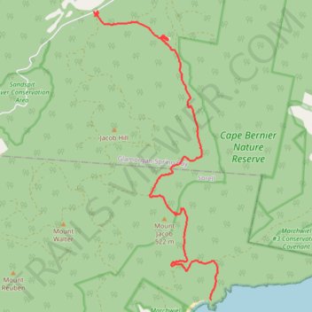
Name: Hike from Bluff Beach via Pony Bottom Track trail, distance, elevation, map, profile, GPS track
Start: Blowhole Point Track, Bream Creek, Tasmania, 7175, Australia (-42.74263 147.90439)
End: Wielangta Road, Rheban, Tasmania, 7190, Australia (-42.68749 147.87389)
Coordinates: -42.74263 147.87389 -42.68749 147.90616
Other hiking, mountain biking, running and outdoor activity trails
Click on a trail to view its statistics, map and profile.
Hike to Bluff Beach via Pony Bottom Track
Distance: 11.9 Km • Elevation gain: 470 m • Maximum elevation: 456 m
HELLFIRE7 04:43:17 PM
Australia > Tasmania > Bream Creek
Distance: 12.3 Km • Elevation gain: 552 m • Maximum elevation: 458 m