Make a donation
Gear up for your next adventure:
As an Amazon Associate, this site earns from qualifying purchases at no extra cost to you.
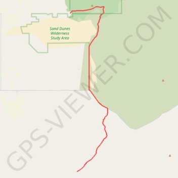
Bend to Alvord Section 2 - Christmas Valley to A6 Intruder Route
- Distance: 39.6 Km
- Elevation gain: 244 m
- Maximum elevation: 1,430 m
- Elevation loss: 125 m
- Minimum elevation: 1,311 m
Interactive trail map
Make a donation
Gear up for your next adventure:
As an Amazon Associate, this site earns from qualifying purchases at no extra cost to you.
Trail profile
- Distance: 39.6 Km
- Elevation gain: 244 m
- Maximum elevation: 1,430 m
- Elevation loss: 125 m
- Minimum elevation: 1,311 m
Make a donation
Gear up for your next adventure:
As an Amazon Associate, this site earns from qualifying purchases at no extra cost to you.
About this trail
Name: Bend to Alvord Section 2 - Christmas Valley to A6 Intruder Route trail, distance, elevation, map, profile, GPS track
Start: Lake County, Oregon, 97736, United States (43.35580 -120.37527)
End: Lake County, Oregon, United States (43.11250 -120.36093)
Coordinates: 43.11250 -120.37527 43.36576 -120.29614
Make a donation
Gear up for your next adventure:
As an Amazon Associate, this site earns from qualifying purchases at no extra cost to you.
Other hiking, mountain biking, running and outdoor activity trails
Click on a trail to view its statistics, map and profile.
Bend to Alvord Section 1 - Bend to Christmas Valley Sand Dunes
United States > Oregon > Deschutes County > Bend
Distance: 158.7 Km • Elevation gain: 887 m • Maximum elevation: 1,559 m