Potato Chip Rock and Mount Woodson Summit from Lake Poway
This hike on Woodson Mountain is a rewarding challenge, offering expansive views of Southern California along the way. As you make your way up the steep trail, you’ll experience a mix of rugged terrain and stunning panoramas that lead to the iconic Potato Chip Rock and the breathtaking Mount Woodson Summit. #Hiking #Mountain #Lake #Nature
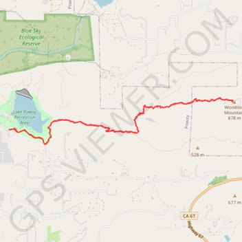
- Distance: 11.6 Km
- Elevation gain: 613 m
- Maximum elevation: 867 m
- Elevation loss: 611 m
- Minimum elevation: 304 m
- Moving time: 2 h 47 m
- Moving speed: 4.2 Km/h
- Maximum speed: 8.0 Km/h
- Total time: 3 h 17 m
- Global speed: 3.5 Km/h
Interactive trail map
Trail profile
- Distance: 11.6 Km
- Elevation gain: 613 m
- Maximum elevation: 867 m
- Elevation loss: 611 m
- Minimum elevation: 304 m
- Moving time: 2 h 47 m
- Moving speed: 4.2 Km/h
- Maximum speed: 8.0 Km/h
- Total time: 3 h 17 m
- Global speed: 3.5 Km/h
About this trail
Name: Potato Chip Rock and Mount Woodson Summit from Lake Poway trail, distance, elevation, map, profile, GPS track
Coordinates: 33.00200 -117.01344 33.00931 -116.97093
Other hiking, mountain biking, running and outdoor activity trails
Click on a trail to view its statistics, map and profile.
Woodson Mountain and Potato Chip Rock via Mount Woodson Road
United States > California > San Diego County
The hike to Potato Chip Rock via Mount Woodson Road offers expansive views of San Diego County and glimpses of the Pacific Ocean on clear days. Along the trail, hikers encounter unique geological formations, notably the famous Potato Chip Rock—a thin, jutting rock resembling a potato chip—which has become…
Distance: 6.7 Km • Elevation gain: 400 m • Maximum elevation: 867 m