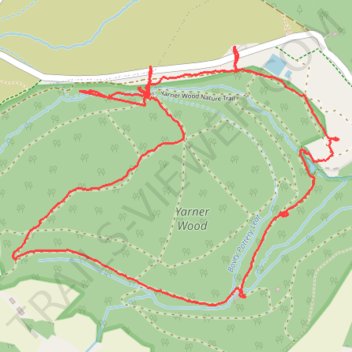
Winter hiking round trip around Yarner Old Reservoir in Dartmoor National Park
- Distance: 5.5 Km
- Elevation gain: 170 m
- Maximum elevation: 244 m
- Elevation loss: 169 m
- Minimum elevation: 112 m
- Moving time: 1 h 26 m
- Moving speed: 3.9 Km/h
- Maximum speed: 60.8 Km/h
- Total time: 2 h 3 m
- Global speed: 2.7 Km/h
Interactive trail map
Trail profile
- Distance: 5.5 Km
- Elevation gain: 170 m
- Maximum elevation: 244 m
- Elevation loss: 169 m
- Minimum elevation: 112 m
- Moving time: 1 h 26 m
- Moving speed: 3.9 Km/h
- Maximum speed: 60.8 Km/h
- Total time: 2 h 3 m
- Global speed: 2.7 Km/h
About this trail
Name: Winter hiking round trip around Yarner Old Reservoir in Dartmoor National Park trail, distance, elevation, map, profile, GPS track
Coordinates: 50.59185 -3.73414 50.60076 -3.71643