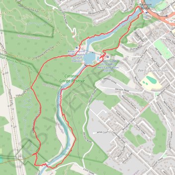
Cataract Circuit
Cataract Gorge Reserve. #Hiking #Loop #CataractGorge #Tasmania
- Distance: 7.1 Km
- Elevation gain: 399 m
- Maximum elevation: 151 m
- Elevation loss: 398 m
- Minimum elevation: 0 m
- Moving time: 57 m 31 s
- Moving speed: 7.4 Km/h
- Maximum speed: 28.6 Km/h
- Total time: 57 m 31 s
- Global speed: 7.4 Km/h
Interactive trail map
Trail profile
- Distance: 7.1 Km
- Elevation gain: 399 m
- Maximum elevation: 151 m
- Elevation loss: 398 m
- Minimum elevation: 0 m
- Moving time: 57 m 31 s
- Moving speed: 7.4 Km/h
- Maximum speed: 28.6 Km/h
- Total time: 57 m 31 s
- Global speed: 7.4 Km/h
About this trail
Name: Cataract Circuit trail, distance, elevation, map, profile, GPS track
Coordinates: -41.45947 147.10951 -41.44001 147.12754