Arch Rock Trail in Joshua Tree National Park
The Arch Rock Trail in Joshua Tree National Park offers a brief yet rewarding hike, leading to the park's renowned Arch Rock. Along the way, hikers can observe unique rock formations, including the distinctive white tank boulders, and a variety of desert flora such as creosote bushes, ocotillo plants, various cacti and Joshua trees. The trail also provides views of the surrounding desert landscape, characterized by rugged terrain and open vistas. #Hiking #Desert #Rock #Nature
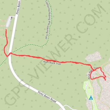
- Distance: 2.1 Km
- Elevation gain: 26 m
- Maximum elevation: 1,193 m
- Elevation loss: 26 m
- Minimum elevation: 1,166 m
- Moving time: 32 m 43 s
- Moving speed: 3.8 Km/h
- Maximum speed: 5.9 Km/h
- Total time: 37 m 7 s
- Global speed: 3.4 Km/h
Interactive trail map
Trail profile
- Distance: 2.1 Km
- Elevation gain: 26 m
- Maximum elevation: 1,193 m
- Elevation loss: 26 m
- Minimum elevation: 1,166 m
- Moving time: 32 m 43 s
- Moving speed: 3.8 Km/h
- Maximum speed: 5.9 Km/h
- Total time: 37 m 7 s
- Global speed: 3.4 Km/h
About this trail
Name: Arch Rock Trail in Joshua Tree National Park trail, distance, elevation, map, profile, GPS track
Start: Twin Tanks, Pinto Basin Road, Riverside County, California, United States (33.98934 -116.02296)
End: Twin Tanks, Pinto Basin Road, Riverside County, California, United States (33.98937 -116.02298)
Coordinates: 33.98622 -116.02312 33.98937 -116.01556
Other hiking, mountain biking, running and outdoor activity trails
Click on a trail to view its statistics, map and profile.
Arch Rock and Heart Rock via Arch Rock Trail in Joshua Tree National Park
United States > California > Riverside County
The Arch Rock Trail in Joshua Tree National Park offers a brief but captivating hiking experience, taking visitors through a vast landscape of unique rock formations and desert terrain. Along the way, hikers encounter the renowned Arch Rock, a natural rock arch that stands as a striking feature of the park,…
Distance: 2.5 Km • Elevation gain: 34 m • Maximum elevation: 1,193 m