12-OCT-21 16:57:46
- Distance: 26.5 Km
- Elevation gain: 1,078 m
- Maximum elevation: 2,329 m
- Elevation loss: 1,078 m
- Minimum elevation: 1,602 m
- Moving time: 5 h 59 m
- Moving speed: 4.4 Km/h
- Maximum speed: 9.5 Km/h
- Total time: 7 h 18 m
- Global speed: 3.6 Km/h
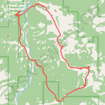
Interactive trail map
Trail profile
- Distance: 26.5 Km
- Elevation gain: 1,078 m
- Maximum elevation: 2,329 m
- Elevation loss: 1,078 m
- Minimum elevation: 1,602 m
- Moving time: 5 h 59 m
- Moving speed: 4.4 Km/h
- Maximum speed: 9.5 Km/h
- Total time: 7 h 18 m
- Global speed: 3.6 Km/h
About this trail
Name: 12-OCT-21 16:57:46 trail, distance, elevation, map, profile, GPS track
Start: Ford Knoll Loop, Kananaskis Improvement District, Alberta, Canada (50.79446 -114.85296)
End: Ford Knoll Loop, Kananaskis Improvement District, Alberta, Canada (50.79439 -114.85294)
Coordinates: 50.72861 -114.85841 50.79956 -114.77317
Topography: Kananaskis Improvement District topographic map, elevation, terrain
Other hiking, mountain biking, running and outdoor activity trails
Click on a trail to view its statistics, map and profile.
Elbow River - Forgetmenot Ridge - Forgetmenot Mountain
Canada > Alberta > Kananaskis Improvement District
Distance: 10.0 Km • Elevation gain: 968 m • Maximum elevation: 2,326 m
Little Elbow to Mount Romulus Campground
Canada > Alberta > Kananaskis Improvement District
Distance: 24.8 Km • Elevation gain: 371 m • Maximum elevation: 1,811 m
Little Elbow to Big Elbow Campground
Canada > Alberta > Kananaskis Improvement District
Distance: 18.4 Km • Elevation gain: 195 m • Maximum elevation: 1,729 m