Thank you for supporting this site ❤️
Make a donation
Make a donation
Gear up for your next adventure:
As an Amazon Associate, this site earns from qualifying purchases at no extra cost to you.
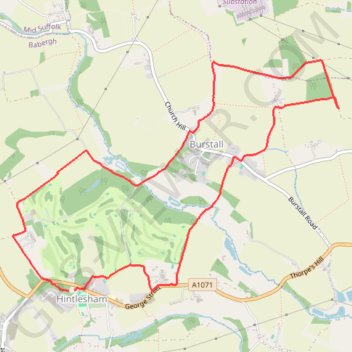
Hintlesham and Burstall loop
- Distance: 8.4 Km
- Elevation gain: 102 m
- Maximum elevation: 61 m
- Elevation loss: 101 m
- Minimum elevation: 19 m
- Moving time: 2 h 3 m
- Moving speed: 4.1 Km/h
- Maximum speed: 6.6 Km/h
- Total time: 2 h 9 m
- Global speed: 3.9 Km/h
Interactive trail map
Thank you for supporting this site ❤️
Make a donation
Make a donation
Gear up for your next adventure:
As an Amazon Associate, this site earns from qualifying purchases at no extra cost to you.
Trail profile
- Distance: 8.4 Km
- Elevation gain: 102 m
- Maximum elevation: 61 m
- Elevation loss: 101 m
- Minimum elevation: 19 m
- Moving time: 2 h 3 m
- Moving speed: 4.1 Km/h
- Maximum speed: 6.6 Km/h
- Total time: 2 h 9 m
- Global speed: 3.9 Km/h
Thank you for supporting this site ❤️
Make a donation
Make a donation
Gear up for your next adventure:
As an Amazon Associate, this site earns from qualifying purchases at no extra cost to you.
About this trail
Name: Hintlesham and Burstall loop trail, distance, elevation, map, profile, GPS track
Coordinates: 52.04981 1.03476 52.06661 1.07325
Thank you for supporting this site ❤️
Make a donation
Make a donation
Gear up for your next adventure:
As an Amazon Associate, this site earns from qualifying purchases at no extra cost to you.