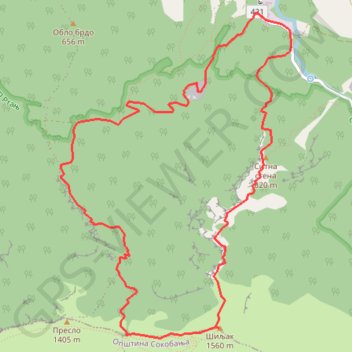
Rtanj: od Mirova, Sitna stena, vrh Šiljak
- Distance: 10.6 Km
- Elevation gain: 1,195 m
- Maximum elevation: 1,547 m
- Elevation loss: 1,195 m
- Minimum elevation: 371 m
- Moving time: 4 h 54 m
- Moving speed: 2.2 Km/h
- Maximum speed: 4.8 Km/h
- Total time: 8 h 23 m
- Global speed: 1.3 Km/h
Interactive trail map
Trail profile
- Distance: 10.6 Km
- Elevation gain: 1,195 m
- Maximum elevation: 1,547 m
- Elevation loss: 1,195 m
- Minimum elevation: 371 m
- Moving time: 4 h 54 m
- Moving speed: 2.2 Km/h
- Maximum speed: 4.8 Km/h
- Total time: 8 h 23 m
- Global speed: 1.3 Km/h
About this trail
Name: Rtanj: od Mirova, Sitna stena, vrh Šiljak trail, distance, elevation, map, profile, GPS track
Coordinates: 43.77528 21.87600 43.80095 21.90126
Other hiking, mountain biking, running and outdoor activity trails
Click on a trail to view its statistics, map and profile.
2022_Yu
Slovenia > Ajdovščina > Žapuže
Distance: 2,457.3 Km • Elevation gain: 32,048 m • Maximum elevation: 1,950 m