Thank you for supporting this site ❤️
Make a donation
Make a donation
Gear up for your next adventure:
As an Amazon Associate, this site earns from qualifying purchases at no extra cost to you.
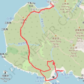
鬼氹
Outdoor hiking
- Distance: 5.9 Km
- Elevation gain: 297 m
- Maximum elevation: 108 m
- Elevation loss: 279 m
- Minimum elevation: 0 m
- Moving time: 1 h 53 m
- Moving speed: 3.1 Km/h
- Maximum speed: 10.3 Km/h
- Total time: 3 h 11 m
- Global speed: 1.9 Km/h
Interactive trail map
Thank you for supporting this site ❤️
Make a donation
Make a donation
Gear up for your next adventure:
As an Amazon Associate, this site earns from qualifying purchases at no extra cost to you.
Trail profile
- Distance: 5.9 Km
- Elevation gain: 297 m
- Maximum elevation: 108 m
- Elevation loss: 279 m
- Minimum elevation: 0 m
- Moving time: 1 h 53 m
- Moving speed: 3.1 Km/h
- Maximum speed: 10.3 Km/h
- Total time: 3 h 11 m
- Global speed: 1.9 Km/h
Thank you for supporting this site ❤️
Make a donation
Make a donation
Gear up for your next adventure:
As an Amazon Associate, this site earns from qualifying purchases at no extra cost to you.
About this trail
Name: 鬼氹 trail, distance, elevation, map, profile, GPS track
Coordinates: 22.24118 114.28359 22.25468 114.29165
Thank you for supporting this site ❤️
Make a donation
Make a donation
Gear up for your next adventure:
As an Amazon Associate, this site earns from qualifying purchases at no extra cost to you.