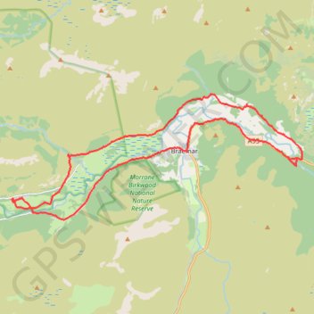
Around Braemar
- Distance: 26.5 Km
- Elevation gain: 313 m
- Maximum elevation: 381 m
- Elevation loss: 313 m
- Minimum elevation: 314 m
- Moving time: 2 h 22 m
- Moving speed: 11.2 Km/h
- Maximum speed: 31.9 Km/h
- Total time: 3 h 10 m
- Global speed: 8.3 Km/h
Interactive trail map
Trail profile
- Distance: 26.5 Km
- Elevation gain: 313 m
- Maximum elevation: 381 m
- Elevation loss: 313 m
- Minimum elevation: 314 m
- Moving time: 2 h 22 m
- Moving speed: 11.2 Km/h
- Maximum speed: 31.9 Km/h
- Total time: 3 h 10 m
- Global speed: 8.3 Km/h
About this trail
Name: Around Braemar trail, distance, elevation, map, profile, GPS track
Coordinates: 56.98620 -3.48992 57.02188 -3.33807
Other hiking, mountain biking, running and outdoor activity trails
Click on a trail to view its statistics, map and profile.
Loop eMTB Gravel: Lin of Dee -> Glen Quoich
United Kingdom > Scotland > Aberdeenshire > Claybokie
Distance: 21.2 Km • Elevation gain: 345 m • Maximum elevation: 496 m