EMTB Gravel: Loch of Grandtully - Loop
Around Loch Grandtully #UK #Perthshire #Aberfeldy #Griffin #Wood
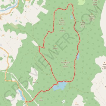
- Distance: 17.9 Km
- Elevation gain: 341 m
- Maximum elevation: 457 m
- Elevation loss: 340 m
- Minimum elevation: 304 m
- Moving time: 1 h 28 m
- Moving speed: 12.2 Km/h
- Maximum speed: 25.5 Km/h
- Total time: 1 h 35 m
- Global speed: 11.2 Km/h
Interactive trail map
Trail profile
- Distance: 17.9 Km
- Elevation gain: 341 m
- Maximum elevation: 457 m
- Elevation loss: 340 m
- Minimum elevation: 304 m
- Moving time: 1 h 28 m
- Moving speed: 12.2 Km/h
- Maximum speed: 25.5 Km/h
- Total time: 1 h 35 m
- Global speed: 11.2 Km/h
About this trail
Name: EMTB Gravel: Loch of Grandtully - Loop trail, distance, elevation, map, profile, GPS track
Start: A826, Aberfeldy, Perth and Kinross, Scotland, PH15 2EL, United Kingdom (56.58520 -3.81551)
End: A826, Aberfeldy, Perth and Kinross, Scotland, PH15 2EL, United Kingdom (56.58518 -3.81537)
Coordinates: 56.58482 -3.81551 56.63832 -3.76200
Other hiking, mountain biking, running and outdoor activity trails
Click on a trail to view its statistics, map and profile.
EMTB: Aberfeldy to Grandtully - Incl Rob Roy Way
United Kingdom > Scotland > Perth and Kinross > Aberfeldy
Loop
Distance: 20.1 Km • Elevation gain: 267 m • Maximum elevation: 146 m