Thank you for supporting this site ❤️
Make a donation
Make a donation
Gear up for your next adventure:
As an Amazon Associate, this site earns from qualifying purchases at no extra cost to you.
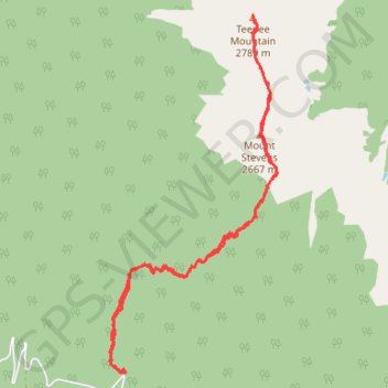
Mount Stevens and Teepee Mountain
Interactive trail map
Thank you for supporting this site ❤️
Make a donation
Make a donation
Gear up for your next adventure:
As an Amazon Associate, this site earns from qualifying purchases at no extra cost to you.
Trail profile
- Distance: 13.8 Km
- Elevation gain: 1,593 m
- Maximum elevation: 2,788 m
- Elevation loss: 1,593 m
- Minimum elevation: 1,307 m
Thank you for supporting this site ❤️
Make a donation
Make a donation
Gear up for your next adventure:
As an Amazon Associate, this site earns from qualifying purchases at no extra cost to you.
About this trail
Name: Mount Stevens and Teepee Mountain trail, distance, elevation, map, profile, GPS track
Coordinates: 49.81468 -115.59974 49.85426 -115.57109
Topography: Area E (Saint Mary/Skookumchuck) topographic map, elevation, terrain
Thank you for supporting this site ❤️
Make a donation
Make a donation
Gear up for your next adventure:
As an Amazon Associate, this site earns from qualifying purchases at no extra cost to you.