עין ושרף פוביצר
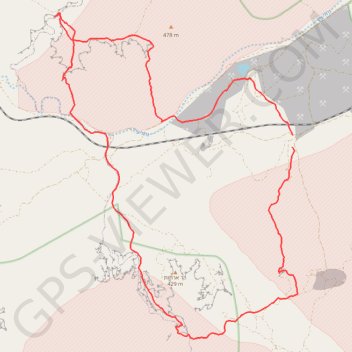
- Distance: 36.5 Km
- Elevation gain: 936 m
- Maximum elevation: 471 m
- Elevation loss: 929 m
- Minimum elevation: 116 m
Interactive trail map
Trail profile
- Distance: 36.5 Km
- Elevation gain: 936 m
- Maximum elevation: 471 m
- Elevation loss: 929 m
- Minimum elevation: 116 m
About this trail
Name: עין ושרף פוביצר trail, distance, elevation, map, profile, GPS track
Start: Arava Tichona Regional Council, Beersheba Subdistrict, South District, Israel (30.80100 35.03313)
Coordinates: 30.74510 34.95703 30.83449 35.03463
Other hiking, mountain biking, running and outdoor activity trails
Click on a trail to view its statistics, map and profile.
Yeruham Crater to Midreshet Ben Gurion
Israel > South District > Ramat Negev Regional Council
מכתש ירוחם למדרשת בן גוריון: מכתש גדול וטעימה ממדבר צין
Distance: 34.3 Km • Elevation gain: 1,311 m • Maximum elevation: 679 m