Blaze the Biblins
Blaze the Biblins, trail race by Monross Trailblazers
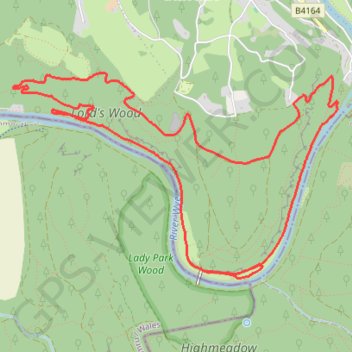
- Distance: 9.2 Km
- Elevation gain: 271 m
- Maximum elevation: 154 m
- Elevation loss: 270 m
- Minimum elevation: 21 m
Interactive trail map
Trail profile
- Distance: 9.2 Km
- Elevation gain: 271 m
- Maximum elevation: 154 m
- Elevation loss: 270 m
- Minimum elevation: 21 m
About this trail
Name: Blaze the Biblins trail, distance, elevation, map, profile, GPS track
End: Peregrine Path, Monmouth, Monmouthshire, Wales, HR9 6DX, United Kingdom (51.82766 -2.65652)
Coordinates: 51.82631 -2.67386 51.83893 -2.64151
Other hiking, mountain biking, running and outdoor activity trails
Click on a trail to view its statistics, map and profile.
Highmeadow Woods loop from Whitchurch
United Kingdom > England > Herefordshire > Symonds Yat West > Great Doward
Distance: 17.0 Km • Elevation gain: 451 m • Maximum elevation: 224 m
Dean2023-311
United Kingdom > England > Oxfordshire > Oxford
Distance: 310.3 Km • Elevation gain: 3,366 m • Maximum elevation: 290 m