Thank you for supporting this site ❤️
Make a donation
Make a donation
Gear up for your next adventure:
As an Amazon Associate, this site earns from qualifying purchases at no extra cost to you.
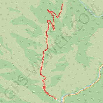
Jardine Juniper Trail
- Distance: 11.5 Km
- Elevation gain: 442 m
- Maximum elevation: 2,051 m
- Elevation loss: 442 m
- Minimum elevation: 1,655 m
Interactive trail map
Thank you for supporting this site ❤️
Make a donation
Make a donation
Gear up for your next adventure:
As an Amazon Associate, this site earns from qualifying purchases at no extra cost to you.
Trail profile
- Distance: 11.5 Km
- Elevation gain: 442 m
- Maximum elevation: 2,051 m
- Elevation loss: 442 m
- Minimum elevation: 1,655 m
Thank you for supporting this site ❤️
Make a donation
Make a donation
Gear up for your next adventure:
As an Amazon Associate, this site earns from qualifying purchases at no extra cost to you.
About this trail
Name: Jardine Juniper Trail trail, distance, elevation, map, profile, GPS track
Start: Wood Camp Hollow, Cache County, Utah, United States (41.79727 -111.64727)
End: Wood Camp Hollow, Cache County, Utah, United States (41.79729 -111.64713)
Coordinates: 41.79727 -111.65335 41.82449 -111.64473
Thank you for supporting this site ❤️
Make a donation
Make a donation
Gear up for your next adventure:
As an Amazon Associate, this site earns from qualifying purchases at no extra cost to you.