Thank you for supporting this site ❤️
Make a donation
Make a donation
Gear up for your next adventure:
As an Amazon Associate, this site earns from qualifying purchases at no extra cost to you.
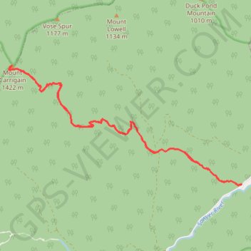
Mount Carrigain
Hike from Sawyer River to Mount Carrigain via Signal Ridge Trail in the White Mountain National Forest. #Hiking #Mountain #Forest #Nature #River
- Distance: 16.4 Km
- Elevation gain: 1,007 m
- Maximum elevation: 1,407 m
- Elevation loss: 1,005 m
- Minimum elevation: 425 m
- Moving time: 4 h 32 m
- Moving speed: 3.6 Km/h
- Maximum speed: 6.4 Km/h
- Total time: 5 h 23 m
- Global speed: 3.0 Km/h
Interactive trail map
Thank you for supporting this site ❤️
Make a donation
Make a donation
Gear up for your next adventure:
As an Amazon Associate, this site earns from qualifying purchases at no extra cost to you.
Trail profile
- Distance: 16.4 Km
- Elevation gain: 1,007 m
- Maximum elevation: 1,407 m
- Elevation loss: 1,005 m
- Minimum elevation: 425 m
- Moving time: 4 h 32 m
- Moving speed: 3.6 Km/h
- Maximum speed: 6.4 Km/h
- Total time: 5 h 23 m
- Global speed: 3.0 Km/h
Thank you for supporting this site ❤️
Make a donation
Make a donation
Gear up for your next adventure:
As an Amazon Associate, this site earns from qualifying purchases at no extra cost to you.
About this trail
Name: Mount Carrigain trail, distance, elevation, map, profile, GPS track
Coordinates: 44.06991 -71.44755 44.09368 -71.38352
Thank you for supporting this site ❤️
Make a donation
Make a donation
Gear up for your next adventure:
As an Amazon Associate, this site earns from qualifying purchases at no extra cost to you.
Other hiking, mountain biking, running and outdoor activity trails
Click on a trail to view its statistics, map and profile.