Pathway in Priorslee
- Distance: 2.9 Km
- Elevation gain: 39 m
- Maximum elevation: 163 m
- Elevation loss: 25 m
- Minimum elevation: 126 m
- Moving time: 30 m 29 s
- Moving speed: 5.8 Km/h
- Maximum speed: 7.7 Km/h
- Total time: 30 m 29 s
- Global speed: 5.8 Km/h
Interactive trail map
Trail profile
- Distance: 2.9 Km
- Elevation gain: 39 m
- Maximum elevation: 163 m
- Elevation loss: 25 m
- Minimum elevation: 126 m
- Moving time: 30 m 29 s
- Moving speed: 5.8 Km/h
- Maximum speed: 7.7 Km/h
- Total time: 30 m 29 s
- Global speed: 5.8 Km/h
About this trail
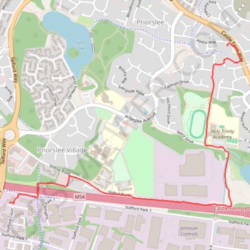
Name: Pathway in Priorslee trail, distance, elevation, map, profile, GPS track
Coordinates: 52.68044 -2.43464 52.68937 -2.41379
Other hiking, mountain biking, running and outdoor activity trails
Click on a trail to view its statistics, map and profile.
Around Priorslee
United Kingdom > England > Telford and Wrekin > Priorslee Village
Distance: 5.5 Km • Elevation gain: 58 m • Maximum elevation: 161 m