Crosland Heath
- Distance: 2.3 Km
- Elevation gain: 46 m
- Maximum elevation: 273 m
- Elevation loss: 45 m
- Minimum elevation: 244 m
- Moving time: 41 m
- Moving speed: 3.3 Km/h
- Maximum speed: 5.4 Km/h
- Total time: 59 m 37 s
- Global speed: 2.3 Km/h
Interactive trail map
Trail profile
- Distance: 2.3 Km
- Elevation gain: 46 m
- Maximum elevation: 273 m
- Elevation loss: 45 m
- Minimum elevation: 244 m
- Moving time: 41 m
- Moving speed: 3.3 Km/h
- Maximum speed: 5.4 Km/h
- Total time: 59 m 37 s
- Global speed: 2.3 Km/h
About this trail
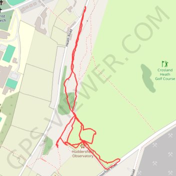
Name: Crosland Heath trail, distance, elevation, map, profile, GPS track
Coordinates: 53.62049 -1.84284 53.62620 -1.83907
Other hiking, mountain biking, running and outdoor activity trails
Click on a trail to view its statistics, map and profile.
Blackmoorfoot reservoir and Crosland Moor
United Kingdom > England > Kirklees > Meltham > Linthwaite > Helme
Distance: 5.1 Km • Elevation gain: 80 m • Maximum elevation: 273 m
Blackmoorfoot and South Crosland loop
United Kingdom > England > Kirklees > Meltham > Linthwaite > Helme
Distance: 5.0 Km • Elevation gain: 72 m • Maximum elevation: 270 m