Make a donation
Gear up for your next adventure:
As an Amazon Associate, this site earns from qualifying purchases at no extra cost to you.
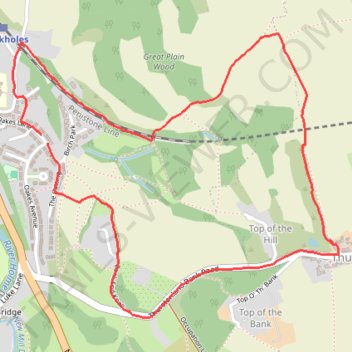
Brockholes and Thurstonland Loop
- Distance: 4.1 Km
- Elevation gain: 144 m
- Maximum elevation: 262 m
- Elevation loss: 141 m
- Minimum elevation: 134 m
- Moving time: 1 h 36 m
- Moving speed: 2.5 Km/h
- Maximum speed: 4.3 Km/h
- Total time: 1 h 59 m
- Global speed: 2.0 Km/h
Interactive trail map
Make a donation
Gear up for your next adventure:
As an Amazon Associate, this site earns from qualifying purchases at no extra cost to you.
Trail profile
- Distance: 4.1 Km
- Elevation gain: 144 m
- Maximum elevation: 262 m
- Elevation loss: 141 m
- Minimum elevation: 134 m
- Moving time: 1 h 36 m
- Moving speed: 2.5 Km/h
- Maximum speed: 4.3 Km/h
- Total time: 1 h 59 m
- Global speed: 2.0 Km/h
Make a donation
Gear up for your next adventure:
As an Amazon Associate, this site earns from qualifying purchases at no extra cost to you.
About this trail
Name: Brockholes and Thurstonland Loop trail, distance, elevation, map, profile, GPS track
Coordinates: 53.58812 -1.76931 53.59683 -1.75248
Make a donation
Gear up for your next adventure:
As an Amazon Associate, this site earns from qualifying purchases at no extra cost to you.
Other hiking, mountain biking, running and outdoor activity trails
Click on a trail to view its statistics, map and profile.
Gate Foot to Farnley Tyas via Thurstonland
United Kingdom > England > Kirklees > Kirkburton
Gate Foot - Snowgate Head - Fulstone - Biggin - Top of the Bank - Thurstonland - Top of the Hill - Farnley Tyas
Distance: 5.8 Km • Elevation gain: 142 m • Maximum elevation: 288 m