Make a donation
Gear up for your next adventure:
As an Amazon Associate, this site earns from qualifying purchases at no extra cost to you.
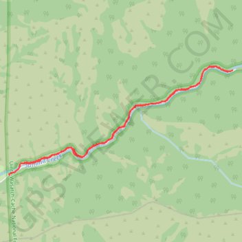
Smithfield Canyon Skiing
Cross country ski along the Smithfield Canyon Road in the Uinta-Wasatch-Cache National Forest and the Mount Naomi Wilderness. #Ski #Mountain #Canyon #Nature #Forest #Wilderness #River
- Distance: 7.4 Km
- Elevation gain: 212 m
- Maximum elevation: 1,848 m
- Elevation loss: 215 m
- Minimum elevation: 1,651 m
- Moving time: 1 h 20 m
- Moving speed: 5.5 Km/h
- Maximum speed: 23.9 Km/h
- Total time: 1 h 38 m
- Global speed: 4.5 Km/h
Interactive trail map
Make a donation
Gear up for your next adventure:
As an Amazon Associate, this site earns from qualifying purchases at no extra cost to you.
Trail profile
- Distance: 7.4 Km
- Elevation gain: 212 m
- Maximum elevation: 1,848 m
- Elevation loss: 215 m
- Minimum elevation: 1,651 m
- Moving time: 1 h 20 m
- Moving speed: 5.5 Km/h
- Maximum speed: 23.9 Km/h
- Total time: 1 h 38 m
- Global speed: 4.5 Km/h
Make a donation
Gear up for your next adventure:
As an Amazon Associate, this site earns from qualifying purchases at no extra cost to you.
About this trail
Name: Smithfield Canyon Skiing trail, distance, elevation, map, profile, GPS track
Start: Smithfield Canyon Road, Cache County, Utah, United States (41.87068 -111.75485)
End: Smithfield Canyon Road, Cache County, Utah, United States (41.86925 -111.75735)
Coordinates: 41.86924 -111.75743 41.88233 -111.72117
Make a donation
Gear up for your next adventure:
As an Amazon Associate, this site earns from qualifying purchases at no extra cost to you.