Thank you for supporting this site ❤️
Make a donation
Make a donation
Gear up for your next adventure:
As an Amazon Associate, this site earns from qualifying purchases at no extra cost to you.
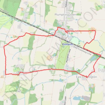
2026-05-12_09-21_Tue-Sue
- Distance: 8.5 Km
- Elevation gain: 69 m
- Maximum elevation: 72 m
- Elevation loss: 69 m
- Minimum elevation: 27 m
- Moving time: 1 h 53 m
- Moving speed: 4.5 Km/h
- Maximum speed: 7.5 Km/h
- Total time: 2 h 21 m
- Global speed: 3.6 Km/h
Interactive trail map
Thank you for supporting this site ❤️
Make a donation
Make a donation
Gear up for your next adventure:
As an Amazon Associate, this site earns from qualifying purchases at no extra cost to you.
Trail profile
- Distance: 8.5 Km
- Elevation gain: 69 m
- Maximum elevation: 72 m
- Elevation loss: 69 m
- Minimum elevation: 27 m
- Moving time: 1 h 53 m
- Moving speed: 4.5 Km/h
- Maximum speed: 7.5 Km/h
- Total time: 2 h 21 m
- Global speed: 3.6 Km/h
Thank you for supporting this site ❤️
Make a donation
Make a donation
Gear up for your next adventure:
As an Amazon Associate, this site earns from qualifying purchases at no extra cost to you.
About this trail
Name: 2026-05-12_09-21_Tue-Sue trail, distance, elevation, map, profile, GPS track
Coordinates: 50.91934 -0.08512 50.93203 -0.04648
Thank you for supporting this site ❤️
Make a donation
Make a donation
Gear up for your next adventure:
As an Amazon Associate, this site earns from qualifying purchases at no extra cost to you.
Other hiking, mountain biking, running and outdoor activity trails
Click on a trail to view its statistics, map and profile.
2026-05-12_09-22_Tue_Peter
United Kingdom > England > East Sussex > Lewes > Plumpton Green
Distance: 8.5 Km • Elevation gain: 72 m • Maximum elevation: 72 m