West Tiger 3 Trail in West Tiger Mountain Natural Resource Conservation Area
The West Tiger 3 Trail is a popular hiking route in the West Tiger Mountain Natural Resource Conservation Area, offering a moderate challenge with a consistent uphill climb through a forest of old-growth trees. The summit, while the lowest of the three West Tiger peaks, provides stunning panoramic views of the surrounding Cascade and Olympic Mountains, as well as Seattle on clear days. Along the trail, hikers may also encounter wildlife, such as owls and deer, and the well-maintained route features multiple alternative trails for those looking to extend their hike. #Hiking #Mountain #Forest #Nature #Overlook
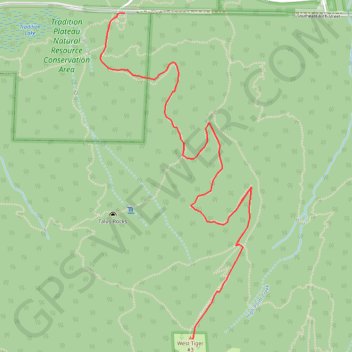
- Distance: 8.2 Km
- Elevation gain: 592 m
- Maximum elevation: 748 m
- Elevation loss: 593 m
- Minimum elevation: 171 m
Interactive trail map
Trail profile
About this trail
Name: West Tiger 3 Trail in West Tiger Mountain Natural Resource Conservation Area trail, distance, elevation, map, profile, GPS track
Start: Tradition Lake Trail, Issaquah, King County, Washington, 98029, United States (47.52932 -121.99636)
Coordinates: 47.51180 -121.99752 47.52956 -121.98533
Other hiking, mountain biking, running and outdoor activity trails
Click on a trail to view its statistics, map and profile.
Tiger Mountain cable trail
United States > Washington > King County > Issaquah
Distance: 10.6 Km • Elevation gain: 732 m • Maximum elevation: 748 m
Tradition Lake Loop in Tradition Plateau Natural Resource Conservation Area
United States > Washington > King County > Issaquah
The Tradition Lake Loop in the Tradition Plateau Natural Resource Conservation Area offers a peaceful hike through dense forests, alongside scenic wetlands and tranquil lake views. Hikers can expect to encounter old-growth trees, varied wildlife like birds and chipmunks, and seasonal wildflowers, making it a…
Distance: 2.3 Km • Elevation gain: 34 m • Maximum elevation: 173 m
West Tiger #3 Trail in West Tiger Mountain Natural Resource Conservation Area
United States > Washington > King County > Issaquah
The West Tiger 3 Trail offers a scenic yet challenging hike through the lush, temperate forest of Tiger Mountain State Forest. As you ascend, you'll encounter a variety of landscapes, including wide, lazy switchbacks and densely vegetated areas filled with ferns and towering trees. The summit rewards hikers…
Distance: 9.0 Km • Elevation gain: 623 m • Maximum elevation: 748 m
West Tiger #3 Loop via Cable Line Trail and West Tiger 3 Trail in Tiger Mountain State Forest
United States > Washington > King County > Issaquah
The West Tiger #3 Loop via Cable Line and West Tiger 3 Trails offers a dynamic, moderately challenging hike with excellent views. The route climbs steadily through forested terrain, with rewarding vistas at the summit, where you'll spot Mount Rainier, the Cascades, and the Olympic Mountains. Along the way,…
Distance: 7.5 Km • Elevation gain: 609 m • Maximum elevation: 748 m
Northern part of the Pacific Crest Trail (PCT)
United States > Oregon > Klamath County
Hike on the Pacific Crest National Scenic Trail from Crater Lake to Canada Border through Oregon and Washington along the Sierra Nevada and Cascade mountain ranges. #Hiking #Mountain #SierraNevada #Cascade #Nature #Forest #Park #PCT
Distance: 1,198.3 Km • Elevation gain: 44,308 m • Maximum elevation: 2,307 m
Talus Rocks
United States > Washington > King County > Issaquah
Hiking Trails
Distance: 9.9 Km • Elevation gain: 493 m • Maximum elevation: 407 m