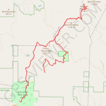
Springer Mountain Loop
Loop hike from Stone Arch to Springer Mountain via East Ridge Trail, Appalachian Approach Trail, Len Foote Trail and Len Foote Hike Inn in the Amicalola Falls State Park and the Chattahoochee-Oconee National Forest. #Hiking #Loop #Mountain #Nature #Forest #Park
- Distance: 25.2 Km
- Elevation gain: 1,218 m
- Maximum elevation: 1,136 m
- Elevation loss: 889 m
- Minimum elevation: 558 m
- Moving time: 6 h 7 m
- Moving speed: 4.1 Km/h
- Maximum speed: 7.4 Km/h
- Total time: 7 h 22 m
- Global speed: 3.4 Km/h
Interactive trail map
Trail profile
- Distance: 25.2 Km
- Elevation gain: 1,218 m
- Maximum elevation: 1,136 m
- Elevation loss: 889 m
- Minimum elevation: 558 m
- Moving time: 6 h 7 m
- Moving speed: 4.1 Km/h
- Maximum speed: 7.4 Km/h
- Total time: 7 h 22 m
- Global speed: 3.4 Km/h
About this trail
Name: Springer Mountain Loop trail, distance, elevation, map, profile, GPS track
Start: East Ridge Trail, Amicalola, Dawson County, Georgia, United States (34.55765 -84.24899)
End: Len Foote Trail, Dawson County, Georgia, United States (34.57804 -84.22728)
Coordinates: 34.55721 -84.24899 34.62670 -84.19166
Other hiking, mountain biking, running and outdoor activity trails
Click on a trail to view its statistics, map and profile.
Amicalola Falls Loop via Creek Trail and East Ridge Trail in Amicalola Falls State Park
United States > Georgia > Dawson County > Amicalola
The Amicalola Falls Loop is a captivating hike offering a mix of natural beauty and a moderate challenge. Starting along a bubbling creek, the trail leads to the park's famed waterfall, with cascading views, lush surroundings, and 600 steps that ascend toward the falls' summit. Hikers can also enjoy…
Distance: 3.4 Km • Elevation gain: 265 m • Maximum elevation: 779 m
Amicalola Falls Loop via Creek Trail and East Ridge Trail in Amicalola Falls State Park
United States > Georgia > Dawson County > Amicalola
The Amicalola Falls Loop offers hikers a diverse experience through Georgia's natural beauty. The Creek Trail leads to the base of the 729-foot Amicalola Falls, providing close-up views of the cascading water and the surrounding lush forest. Ascending the East Ridge Trail, hikers are treated to panoramic…
Distance: 3.3 Km • Elevation gain: 255 m • Maximum elevation: 778 m
North Georgia roads and trails to Springer Mountain via Benton MacKaye Trail in the Blue Ridge Wildlife Management Area
United States > Georgia > Lumpkin County > Dahlonega
Distance: 80.0 Km • Elevation gain: 2,068 m • Maximum elevation: 1,137 m