Thank you for supporting this site ❤️
Make a donation
Make a donation
Gear up for your next adventure:
As an Amazon Associate, this site earns from qualifying purchases at no extra cost to you.
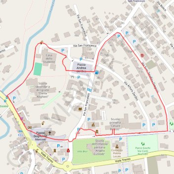
Fiume veneto
- Distance: 1.7 Km
- Elevation gain: 2 m
- Maximum elevation: 23 m
- Elevation loss: 2 m
- Minimum elevation: 21 m
Interactive trail map
Thank you for supporting this site ❤️
Make a donation
Make a donation
Gear up for your next adventure:
As an Amazon Associate, this site earns from qualifying purchases at no extra cost to you.
Trail profile
- Distance: 1.7 Km
- Elevation gain: 2 m
- Maximum elevation: 23 m
- Elevation loss: 2 m
- Minimum elevation: 21 m
Thank you for supporting this site ❤️
Make a donation
Make a donation
Gear up for your next adventure:
As an Amazon Associate, this site earns from qualifying purchases at no extra cost to you.
About this trail
Name: Fiume veneto trail, distance, elevation, map, profile, GPS track
Coordinates: 45.92773 12.73090 45.93095 12.73771
Thank you for supporting this site ❤️
Make a donation
Make a donation
Gear up for your next adventure:
As an Amazon Associate, this site earns from qualifying purchases at no extra cost to you.