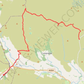
Hike from Buttertubs Pass to Garsdale via Great Shunner Fell and Lunds Fell
- Distance: 19.8 Km
- Elevation gain: 394 m
- Maximum elevation: 716 m
- Elevation loss: 572 m
- Minimum elevation: 307 m
- Moving time: 5 h 19 m
- Moving speed: 3.7 Km/h
- Maximum speed: 37.2 Km/h
- Total time: 6 h 49 m
- Global speed: 2.9 Km/h
Interactive trail map
Trail profile
- Distance: 19.8 Km
- Elevation gain: 394 m
- Maximum elevation: 716 m
- Elevation loss: 572 m
- Minimum elevation: 307 m
- Moving time: 5 h 19 m
- Moving speed: 3.7 Km/h
- Maximum speed: 37.2 Km/h
- Total time: 6 h 49 m
- Global speed: 2.9 Km/h
About this trail
Name: Hike from Buttertubs Pass to Garsdale via Great Shunner Fell and Lunds Fell trail, distance, elevation, map, profile, GPS track
Coordinates: 54.32052 -2.32855 54.38389 -2.20290