Thank you for supporting this site ❤️
Make a donation
Make a donation
Gear up for your next adventure:
As an Amazon Associate, this site earns from qualifying purchases at no extra cost to you.
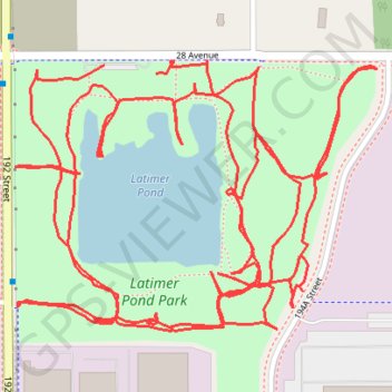
Latimer Pond
- Distance: 6.1 Km
- Elevation gain: 27 m
- Maximum elevation: 55 m
- Elevation loss: 26 m
- Minimum elevation: 43 m
- Moving time: 1 h 51 m
- Moving speed: 3.3 Km/h
- Maximum speed: 5.2 Km/h
- Total time: 2 h 15 m
- Global speed: 2.7 Km/h
Interactive trail map
Thank you for supporting this site ❤️
Make a donation
Make a donation
Gear up for your next adventure:
As an Amazon Associate, this site earns from qualifying purchases at no extra cost to you.
Trail profile
- Distance: 6.1 Km
- Elevation gain: 27 m
- Maximum elevation: 55 m
- Elevation loss: 26 m
- Minimum elevation: 43 m
- Moving time: 1 h 51 m
- Moving speed: 3.3 Km/h
- Maximum speed: 5.2 Km/h
- Total time: 2 h 15 m
- Global speed: 2.7 Km/h
Thank you for supporting this site ❤️
Make a donation
Make a donation
Gear up for your next adventure:
As an Amazon Associate, this site earns from qualifying purchases at no extra cost to you.
About this trail
Name: Latimer Pond trail, distance, elevation, map, profile, GPS track
Coordinates: 49.04885 -122.69132 49.05282 -122.68322
Topography: Surrey topographic map, elevation, terrain
Thank you for supporting this site ❤️
Make a donation
Make a donation
Gear up for your next adventure:
As an Amazon Associate, this site earns from qualifying purchases at no extra cost to you.
Other hiking, mountain biking, running and outdoor activity trails
Click on a trail to view its statistics, map and profile.
Tsawwassen - Chilliwack
Canada > British Columbia > Metro Vancouver Regional District
Distance: 98.7 Km • Elevation gain: 500 m • Maximum elevation: 126 m