Thank you for supporting this site ❤️
Make a donation
Make a donation
Gear up for your next adventure:
As an Amazon Associate, this site earns from qualifying purchases at no extra cost to you.
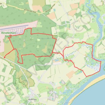
Suffolk Coastal Trail Running
Woodbridge
- Distance: 22.0 Km
- Elevation gain: 118 m
- Maximum elevation: 28 m
- Elevation loss: 118 m
- Minimum elevation: -3 m
- Moving time: 2 h 28 m
- Moving speed: 8.9 Km/h
- Maximum speed: 15.7 Km/h
- Total time: 2 h 33 m
- Global speed: 8.6 Km/h
Interactive trail map
Thank you for supporting this site ❤️
Make a donation
Make a donation
Gear up for your next adventure:
As an Amazon Associate, this site earns from qualifying purchases at no extra cost to you.
Trail profile
- Distance: 22.0 Km
- Elevation gain: 118 m
- Maximum elevation: 28 m
- Elevation loss: 118 m
- Minimum elevation: -3 m
- Moving time: 2 h 28 m
- Moving speed: 8.9 Km/h
- Maximum speed: 15.7 Km/h
- Total time: 2 h 33 m
- Global speed: 8.6 Km/h
Thank you for supporting this site ❤️
Make a donation
Make a donation
Gear up for your next adventure:
As an Amazon Associate, this site earns from qualifying purchases at no extra cost to you.
About this trail
Name: Suffolk Coastal Trail Running trail, distance, elevation, map, profile, GPS track
Coordinates: 52.06175 1.40505 52.09016 1.49715
Thank you for supporting this site ❤️
Make a donation
Make a donation
Gear up for your next adventure:
As an Amazon Associate, this site earns from qualifying purchases at no extra cost to you.
Other hiking, mountain biking, running and outdoor activity trails
Click on a trail to view its statistics, map and profile.
Tunstall Forest and Rendlesham Forest Loop from Bawdsey Manor
United Kingdom > England > Suffolk > East Suffolk > Bawdsey
Distance: 65.2 Km • Elevation gain: 403 m • Maximum elevation: 34 m