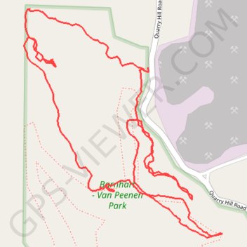
Barnhart - Van Peenen Park Loop
- Distance: 3.4 Km
- Elevation gain: 59 m
- Maximum elevation: 341 m
- Elevation loss: 59 m
- Minimum elevation: 314 m
- Moving time: 51 m 17 s
- Moving speed: 4.0 Km/h
- Maximum speed: 8.5 Km/h
- Total time: 1 h 10 m
- Global speed: 2.9 Km/h
Interactive trail map
Trail profile
- Distance: 3.4 Km
- Elevation gain: 59 m
- Maximum elevation: 341 m
- Elevation loss: 59 m
- Minimum elevation: 314 m
- Moving time: 51 m 17 s
- Moving speed: 4.0 Km/h
- Maximum speed: 8.5 Km/h
- Total time: 1 h 10 m
- Global speed: 2.9 Km/h
About this trail
Name: Barnhart - Van Peenen Park Loop trail, distance, elevation, map, profile, GPS track
Start: The Prarie, Winneshiek County, Iowa, 52101, United States (43.31890 -91.77329)
End: The Prarie, Winneshiek County, Iowa, 52101, United States (43.31885 -91.77343)
Coordinates: 43.31444 -91.77775 43.32043 -91.77061