Thank you for supporting this site ❤️
Make a donation
Make a donation
Gear up for your next adventure:
As an Amazon Associate, this site earns from qualifying purchases at no extra cost to you.
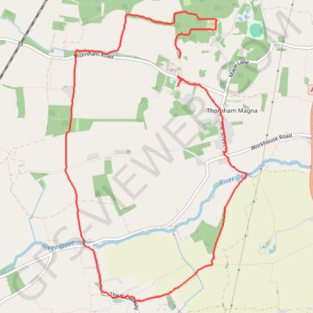
Thornham Walks
thornham-walks, wickham-skeith, thornham-magna
- Distance: 8.9 Km
- Elevation gain: 58 m
- Maximum elevation: 59 m
- Elevation loss: 61 m
- Minimum elevation: 38 m
- Moving time: 2 h 9 m
- Moving speed: 4.1 Km/h
- Maximum speed: 18.8 Km/h
- Total time: 3 h 46 m
- Global speed: 2.3 Km/h
Interactive trail map
Thank you for supporting this site ❤️
Make a donation
Make a donation
Gear up for your next adventure:
As an Amazon Associate, this site earns from qualifying purchases at no extra cost to you.
Trail profile
- Distance: 8.9 Km
- Elevation gain: 58 m
- Maximum elevation: 59 m
- Elevation loss: 61 m
- Minimum elevation: 38 m
- Moving time: 2 h 9 m
- Moving speed: 4.1 Km/h
- Maximum speed: 18.8 Km/h
- Total time: 3 h 46 m
- Global speed: 2.3 Km/h
Thank you for supporting this site ❤️
Make a donation
Make a donation
Gear up for your next adventure:
As an Amazon Associate, this site earns from qualifying purchases at no extra cost to you.
About this trail
Name: Thornham Walks trail, distance, elevation, map, profile, GPS track
Coordinates: 52.28161 1.06174 52.30685 1.08763
Thank you for supporting this site ❤️
Make a donation
Make a donation
Gear up for your next adventure:
As an Amazon Associate, this site earns from qualifying purchases at no extra cost to you.