Import a GPX file

Perimeter Trail at Southeast Park

  • Distance: 2.9 Km
  • Elevation gain: 28 m
  • Maximum elevation: 80 m
  • Elevation loss: 28 m
  • Minimum elevation: 65 m
  • Moving time: 52 m 6 s
  • Moving speed: 3.3 Km/h
  • Maximum speed: 3.8 Km/h
  • Total time: 52 m 6 s
  • Global speed: 3.3 Km/h

Interactive trail map

Trail profile

  • Distance: 2.9 Km
  • Elevation gain: 28 m
  • Maximum elevation: 80 m
  • Elevation loss: 28 m
  • Minimum elevation: 65 m
  • Moving time: 52 m 6 s
  • Moving speed: 3.3 Km/h
  • Maximum speed: 3.8 Km/h
  • Total time: 52 m 6 s
  • Global speed: 3.3 Km/h

About this trail
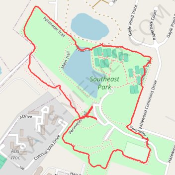
Name: Perimeter Trail at Southeast Park trail, distance, elevation, map, profile, GPS track

Start: Main Trail, Hazelwood Acres, Richland County, South Carolina, 29209, United States (33.96107 -80.93260)

End: Main Trail, Hazelwood Acres, Richland County, South Carolina, 29209, United States (33.96107 -80.93260)

Coordinates: 33.95913 -80.93607 33.96555 -80.93001

Gear up for your next adventure:

⛺Camping Groundsheet - Protect your tent from moisture and dirt
🧥Fleece Jacket - Warm and lightweight jacket for layering
🦯Trekking Poles - Reduced impact on joints for steep topographic climbs
🔋Lithium AA Batteries - Long-lasting power that performs in extreme cold
🛏️Camping Sleeping Mat - Comfortable mats for sleeping outdoors

As an Amazon Associate, this site earns from qualifying purchases at no extra cost to you.