La Luz Trail in Sandia Mountain Wilderness
The La Luz Trail is a breathtaking journey that transforms from high desert landscapes to lush pine forests as you ascend toward Sandia Peak. Hikers are treated to stunning panoramic views of Albuquerque and the surrounding mountains, especially near the scenic overlook, where wildflowers add a splash of color during the summer months. Although the trail can be challenging, particularly with rocky sections and a steep incline, the sense of accomplishment upon reaching the summit and the option to ride the Sandia Peak Tramway back down makes it an unforgettable adventure. #Hiking #Mountain #Forest #Nature
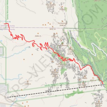
- Distance: 24.7 Km
- Elevation gain: 1,432 m
- Maximum elevation: 3,139 m
- Elevation loss: 1,431 m
- Minimum elevation: 2,137 m
- Moving time: 5 h 39 m
- Moving speed: 4.4 Km/h
- Maximum speed: 8.4 Km/h
- Total time: 8 h 36 m
- Global speed: 2.9 Km/h
Interactive trail map
Trail profile
- Distance: 24.7 Km
- Elevation gain: 1,432 m
- Maximum elevation: 3,139 m
- Elevation loss: 1,431 m
- Minimum elevation: 2,137 m
- Moving time: 5 h 39 m
- Moving speed: 4.4 Km/h
- Maximum speed: 8.4 Km/h
- Total time: 8 h 36 m
- Global speed: 2.9 Km/h
About this trail
Name: La Luz Trail in Sandia Mountain Wilderness trail, distance, elevation, map, profile, GPS track
Start: La Luz Trail, Sandoval County, New Mexico, United States (35.21925 -106.48116)
End: La Luz Trailhead, La Luz Trail, Sandoval County, New Mexico, United States (35.21933 -106.48115)
Coordinates: 35.19596 -106.48117 35.21946 -106.43397
Other hiking, mountain biking, running and outdoor activity trails
Click on a trail to view its statistics, map and profile.
Challenge Trail
United States > New Mexico > Bernalillo County
Distance: 22.9 Km • Elevation gain: 243 m • Maximum elevation: 3,244 m
King of the Mountain Loop Trail in Cibola National Forest
United States > New Mexico > Bernalillo County
Distance: 6.2 Km • Elevation gain: 220 m • Maximum elevation: 3,105 m
Northcourse and Capulin Peak
United States > New Mexico > Bernalillo County
Distance: 6.4 Km • Elevation gain: 124 m • Maximum elevation: 3,037 m