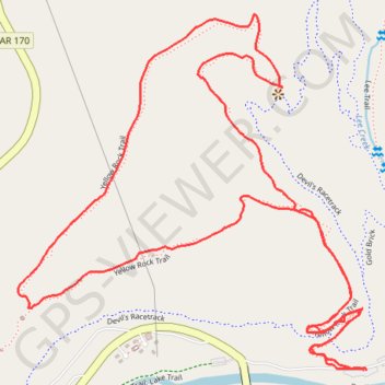
Yellow Rock Loop Trail in Devil's Den State Park
The Yellow Rock Loop Trail offers a captivating hiking experience characterized by unique rock formations, scenic overlooks, and a blend of shaded woodland paths. As you ascend, you'll encounter a variety of natural features, including sandstone crevices and bluffs, leading to the impressive Yellow Rock Overlook, which provides panoramic views of the Lee Creek Valley. The trail is well-maintained and features both flat and steep sections, making it suitable for moderately experienced hikers looking to explore the beautiful Arkansas Ozarks. #Hiking #Loop #Rock #Mountain #Forest #Nature
- Distance: 4.3 Km
- Elevation gain: 165 m
- Maximum elevation: 438 m
- Elevation loss: 166 m
- Minimum elevation: 316 m
- Moving time: 1 h 8 m
- Moving speed: 3.8 Km/h
- Maximum speed: 7.0 Km/h
- Total time: 1 h 16 m
- Global speed: 3.4 Km/h
Interactive trail map
Trail profile
- Distance: 4.3 Km
- Elevation gain: 165 m
- Maximum elevation: 438 m
- Elevation loss: 166 m
- Minimum elevation: 316 m
- Moving time: 1 h 8 m
- Moving speed: 3.8 Km/h
- Maximum speed: 7.0 Km/h
- Total time: 1 h 16 m
- Global speed: 3.4 Km/h
About this trail
Name: Yellow Rock Loop Trail in Devil's Den State Park trail, distance, elevation, map, profile, GPS track
Start: Yellow Rock Trail, Washington County, Arkansas, United States (35.78203 -94.24631)
End: Yellow Rock Trail, Washington County, Arkansas, United States (35.78203 -94.24625)
Coordinates: 35.78203 -94.25511 35.78938 -94.24625
Other hiking, mountain biking, running and outdoor activity trails
Click on a trail to view its statistics, map and profile.
Devil's Den Loop Trail in Devil's Den State Park
United States > Arkansas > Washington County
The Devil's Den Loop Trail offers a dynamic hiking experience through the rugged terrain of the Ozark Mountains. This moderate trail features stunning rock formations, including Devil's Den Cave and crevices, and the chance to see seasonal waterfalls along with lush plant life. With its mix of natural beauty,…
Distance: 1.8 Km • Elevation gain: 52 m • Maximum elevation: 359 m