Thank you for supporting this site ❤️
Make a donation
Make a donation
Gear up for your next adventure:
As an Amazon Associate, this site earns from qualifying purchases at no extra cost to you.
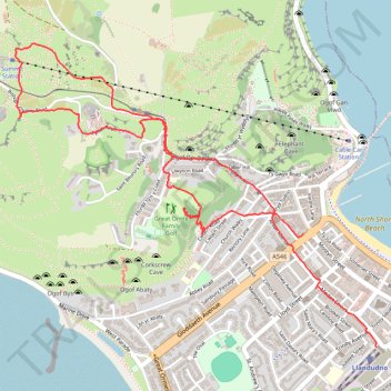
Great Orme
- Distance: 5.5 Km
- Elevation gain: 233 m
- Maximum elevation: 204 m
- Elevation loss: 230 m
- Minimum elevation: 7 m
- Moving time: 1 h 29 m
- Moving speed: 3.7 Km/h
- Maximum speed: 7.2 Km/h
- Total time: 2 h 6 m
- Global speed: 2.6 Km/h
Interactive trail map
Thank you for supporting this site ❤️
Make a donation
Make a donation
Gear up for your next adventure:
As an Amazon Associate, this site earns from qualifying purchases at no extra cost to you.
Trail profile
- Distance: 5.5 Km
- Elevation gain: 233 m
- Maximum elevation: 204 m
- Elevation loss: 230 m
- Minimum elevation: 7 m
- Moving time: 1 h 29 m
- Moving speed: 3.7 Km/h
- Maximum speed: 7.2 Km/h
- Total time: 2 h 6 m
- Global speed: 2.6 Km/h
Thank you for supporting this site ❤️
Make a donation
Make a donation
Gear up for your next adventure:
As an Amazon Associate, this site earns from qualifying purchases at no extra cost to you.
About this trail
Name: Great Orme trail, distance, elevation, map, profile, GPS track
Coordinates: 53.32074 -3.85272 53.33348 -3.82735
Thank you for supporting this site ❤️
Make a donation
Make a donation
Gear up for your next adventure:
As an Amazon Associate, this site earns from qualifying purchases at no extra cost to you.
Other hiking, mountain biking, running and outdoor activity trails
Click on a trail to view its statistics, map and profile.
Great Orme Summit and Loop
United Kingdom > Wales > Conwy > Llandudno
Distance: 9.4 Km • Elevation gain: 357 m • Maximum elevation: 204 m