Make a donation
Gear up for your next adventure:
As an Amazon Associate, this site earns from qualifying purchases at no extra cost to you.
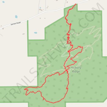
Sanctuary trail walk in Hickory Ridge
- Distance: 6.9 Km
- Elevation gain: 148 m
- Maximum elevation: 570 m
- Elevation loss: 150 m
- Minimum elevation: 459 m
- Moving time: 1 h 31 m
- Moving speed: 4.5 Km/h
- Maximum speed: 9.0 Km/h
- Total time: 2 h 40 m
- Global speed: 2.6 Km/h
Interactive trail map
Make a donation
Gear up for your next adventure:
As an Amazon Associate, this site earns from qualifying purchases at no extra cost to you.
Trail profile
- Distance: 6.9 Km
- Elevation gain: 148 m
- Maximum elevation: 570 m
- Elevation loss: 150 m
- Minimum elevation: 459 m
- Moving time: 1 h 31 m
- Moving speed: 4.5 Km/h
- Maximum speed: 9.0 Km/h
- Total time: 2 h 40 m
- Global speed: 2.6 Km/h
Make a donation
Gear up for your next adventure:
As an Amazon Associate, this site earns from qualifying purchases at no extra cost to you.
About this trail
Name: Sanctuary trail walk in Hickory Ridge trail, distance, elevation, map, profile, GPS track
Start: Homestead, Town of Naples, Ontario County, New York, 14512, United States (42.66167 -77.39599)
Coordinates: 42.64703 -77.40629 42.66172 -77.39449
Make a donation
Gear up for your next adventure:
As an Amazon Associate, this site earns from qualifying purchases at no extra cost to you.
Other hiking, mountain biking, running and outdoor activity trails
Click on a trail to view its statistics, map and profile.
Sanctuary Trail Mountain Bike Ride in Hickory Ridge
United States > New York > Ontario County > Town of Naples > Semans Corner
Distance: 8.7 Km • Elevation gain: 164 m • Maximum elevation: 570 m