Import a GPX file

Mansfield Bike Path

#Bike #Loop #Road #Forest #Nature

  • Distance: 5.5 Km
  • Elevation gain: 65 m
  • Maximum elevation: 258 m
  • Elevation loss: 65 m
  • Minimum elevation: 210 m

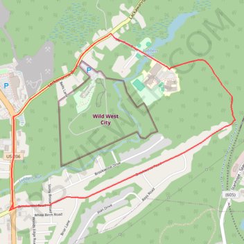
Interactive trail map

Trail profile

  • Distance: 5.5 Km
  • Elevation gain: 65 m
  • Maximum elevation: 258 m
  • Elevation loss: 65 m
  • Minimum elevation: 210 m

About this trail

Gear up for your next adventure:

🧦Merino Wool Socks - Moisture-wicking comfort for long-distance hiking
🔦UV Flashlight - Detect minerals or specific insects in the dark
💡Portable Camping Lamp - Rechargeable lamp for campsite lighting
🧴Outdoor Sunscreen - High SPF protection for high-altitude UV exposure
🧴Sunscreen SPF - Broad-spectrum sunscreen for outdoor activities

As an Amazon Associate, this site earns from qualifying purchases at no extra cost to you.