Import a GPX file

Baltimore spin

#Bike #Loop

  • Distance: 94.9 Km
  • Elevation gain: 1,411 m
  • Maximum elevation: 123 m
  • Elevation loss: 1,410 m
  • Minimum elevation: 0 m

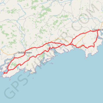
Interactive trail map

Trail profile

  • Distance: 94.9 Km
  • Elevation gain: 1,411 m
  • Maximum elevation: 123 m
  • Elevation loss: 1,410 m
  • Minimum elevation: 0 m

About this trail

Gear up for your next adventure:

🥾Mountain Hiking Boots - High-traction boots for rocky terrain
🧰Emergency Multi-Tool - Compact multi-tool for outdoor survival
🔪Outdoor Multitool - Versatile tool for repairs and food prep in the wild
🚲Heavy Duty Bike Lock - Secure your bike at the trailhead or during stops
🔦LED Headlamp - Hands-free lighting for early morning starts or late finishes

As an Amazon Associate, this site earns from qualifying purchases at no extra cost to you.