Make a donation
Gear up for your next adventure:
As an Amazon Associate, this site earns from qualifying purchases at no extra cost to you.
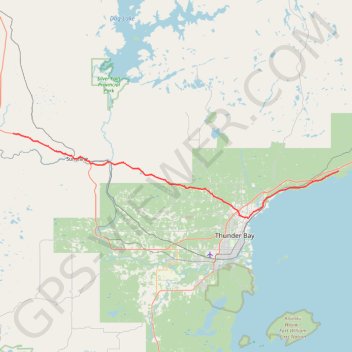
Shebandowan - Shuniah
Lake Superior. #Bike #Shebandowan #Shuniah #LakeSuperior
- Distance: 75.1 Km
- Elevation gain: 506 m
- Maximum elevation: 457 m
- Elevation loss: 710 m
- Minimum elevation: 188 m
Interactive trail map
Make a donation
Gear up for your next adventure:
As an Amazon Associate, this site earns from qualifying purchases at no extra cost to you.
Trail profile
- Distance: 75.1 Km
- Elevation gain: 506 m
- Maximum elevation: 457 m
- Elevation loss: 710 m
- Minimum elevation: 188 m
Make a donation
Gear up for your next adventure:
As an Amazon Associate, this site earns from qualifying purchases at no extra cost to you.
About this trail
Name: Shebandowan - Shuniah trail, distance, elevation, map, profile, GPS track
Coordinates: 48.43573 -89.85781 48.58853 -88.97785
Topography: Unorganized Thunder Bay District topographic map, elevation, terrain
Make a donation
Gear up for your next adventure:
As an Amazon Associate, this site earns from qualifying purchases at no extra cost to you.
Other hiking, mountain biking, running and outdoor activity trails
Click on a trail to view its statistics, map and profile.
Shebandowan - Shuniah
Canada > Ontario > Thunder Bay District > Unorganized Thunder Bay District > Sunshine
Distance: 93.4 Km • Elevation gain: 484 m • Maximum elevation: 445 m