Mont Perdu - Gavernie
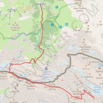
Interactive trail map
Trail profile
- Distance: 15.1 Km
- Elevation gain: 446 m
- Maximum elevation: 3,332 m
- Elevation loss: 2,403 m
- Minimum elevation: 1,374 m
About this trail
Name: Mont Perdu - Gavernie trail, distance, elevation, map, profile, GPS track
Start: Camino de Monte Perido, Bielsa, Sobrarbe, Huesca, Aragon, Spain (42.67578 0.03445)
Coordinates: 42.67507 -0.03489 42.73221 0.03454
Other hiking, mountain biking, running and outdoor activity trails
Click on a trail to view its statistics, map and profile.
Southern section — European Divide Trail
France > Auvergne-Rhône-Alpes > Drôme > Valence
Distance: 2,423.8 Km • Elevation gain: 42,375 m • Maximum elevation: 2,005 m
GR 10 - Traversée des Pyrénées
France > Occitania > Pyrénées-Orientales > Banyuls-sur-Mer
Distance: 874.8 Km • Elevation gain: 57,000 m • Maximum elevation: 2,599 m
1 LUCENA - MONTPELLIER
Distance: 2,964.4 Km • Elevation gain: 29,500 m • Maximum elevation: 1,048 m
Day 4 Gavarnie from Hotellerie to Grande Cascade
France > Occitania > Hautes Pyrenees > Gavarnie-Gèdre > Gavarnie
Distance: 1.2 Km • Elevation gain: 216 m • Maximum elevation: 1,787 m
Day 4 Harder walking - Espugues path
France > Occitania > Hautes Pyrenees > Gavarnie-Gèdre > Gavarnie
Distance: 4.6 Km • Elevation gain: 354 m • Maximum elevation: 1,810 m
Day 4 Standard route at Gavarnie
France > Occitania > Hautes Pyrenees > Gavarnie-Gèdre > Gavarnie
Distance: 10.1 Km • Elevation gain: 495 m • Maximum elevation: 1,707 m