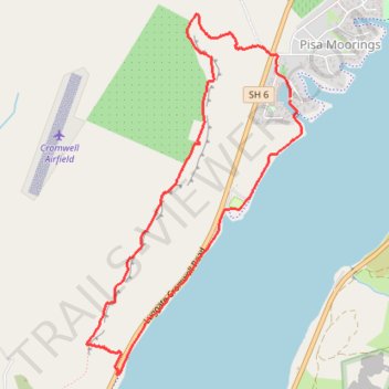
Pisa Moorings Loop Run
- Distance: 7.1 Km
- Elevation gain: 169 m
- Maximum elevation: 318 m
- Elevation loss: 170 m
- Minimum elevation: 196 m
- Moving time: 1 h 6 m
- Moving speed: 6.3 Km/h
- Maximum speed: 11.8 Km/h
- Total time: 1 h 13 m
- Global speed: 5.7 Km/h
Interactive trail map
Trail profile
- Distance: 7.1 Km
- Elevation gain: 169 m
- Maximum elevation: 318 m
- Elevation loss: 170 m
- Minimum elevation: 196 m
- Moving time: 1 h 6 m
- Moving speed: 6.3 Km/h
- Maximum speed: 11.8 Km/h
- Total time: 1 h 13 m
- Global speed: 5.7 Km/h
About this trail
Name: Pisa Moorings Loop Run trail, distance, elevation, map, profile, GPS track
Coordinates: -44.99833 169.21869 -44.97504 169.23835
Other hiking, mountain biking, running and outdoor activity trails
Click on a trail to view its statistics, map and profile.